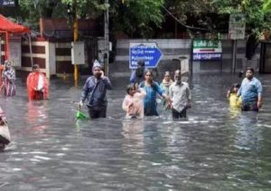
Several areas are inundated in Chennai due to heavy rains. (Photo credit: PTI)
There was a bit of relief for residents of Chennai on Monday evening as the city & suburbs saw a slight reduction in rains. While the daytime saw mostly dry conditions, there was a moderate to heavy spell of rains that gripped most parts of the city late in the night closer to midnight. About 40 kilometres to the south of Chennai, the coast of Mahabalipuram recorded more than 10 cm of rainfall. But overall, the rainfall was slightly subdued compared to Sunday which saw record rainfall prompting authorities to open up sluice gates of three city reservoirs to let out surplus water.
This could just be the calm before the storm as weathermen predict that a low pressure system is likely to form in the next 24 hours which will concentrate into a depression and move towards the North Tamil Nadu coast by November 11.
Partially, the effect of upper air cyclonic circulation (UAC) merging with the South Bay UAC was the reason for the reduction in rains. While the UAC was persisting off the coast, it created wind convergence to trigger thunderstorms. Once the UAC faded and transferred its energy to the South Bay pulse, the coast saw an advent of just Northerlies without the Easterlies which resulted in reduction of rains contrary to the model expectations. It is pertinent to note that possibly yesterday’s events happened quicker than the model estimates, though we need to see if today’s events confirm that.


 Driving Naari Programme launched in Chandigarh


